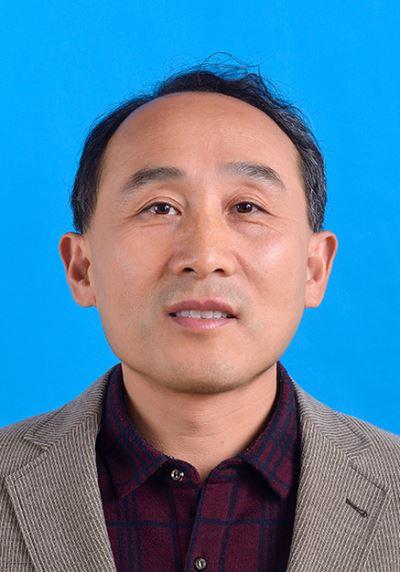
张磊,男,1965年出生,江苏宜兴人,博士,研究员。长期致力于土地覆盖遥感监测研究,探索土地覆盖分类方法与制图。开展多尺度对象特征分类方法研究。基于视觉理论、大脑认知理论,研究影像对象特征、土地覆盖结构、尺度推绎的之间关联性,通过尺度优化,改进分类精度。开展国家中尺度的土地覆盖制图的分类算法、变化检测、精度验证,及发展工程化集成的技术体系与方法。现为《Remote Sensing Letters》、《Journal of Applied Remote Sensing》期刊评审专家。先后发表论文50多篇,其中SCI论文9篇。
教育经历:
1982.09-1986.07,北京大学,地貌与第四纪地质学,理学学士
2000.09-2002.03,荷兰国际地理信息科学与地球观测学院(ITC),海岸带研究,理学硕士
2005.09-2011.07,中国科学院遥感应用研究所,土地覆盖研究,理学博士
科研工作经历:
1986.07-现在,中国科学院遥感与数字地球研究所
[1] Lei Zhang, Bingfang Wu, Kai Yin, Xiaosong Li, Kun Kia, Liang Zhu (2015) Impacts of human activities on the evolution of estuarine wetland in the Yangtze Delta from 2000 to 2010. Environ Earth Sci 73(1) (SCI检索)
[2] Z. Lei, W. Bingfang, Z. Liang, and W. Peng (2012) Patterns and driving forces of cropland changes in the Three Gorges Area, China. Regional Environmental Change, vol. 12, no. 4, 765-776 (SCI检索)
[3] Lei Zhang, Kun Jia, Xiaosong Li, Quanzhi Yuan, and Xinfeng Zhao. Multi-scale segmentation approach for object-based land-cover classification using high-resolution imagery. Remote Sensing Letters, 2014, Vol. 5, No. 1, 73–82 (SCI检索)
[4] Lei Zhang, Xiaosong Li, Quanzhi Yuan, and Yu Liu. An object-based approach to national land cover mapping using HJ satellite imagery. Journal of Applied Remote Sensing, 2014, Vol. 8(1), 1-19(SCI检索)
[5] 张磊,赵健龙,贾坤,李晓松. 基于物候特征的植物光谱识别方法研究. 光谱学与光谱分析. 2015,35(10)(SCI检索)
[6] LI Xiao-song, WU Bing-fang, ZHANG Lei. Dynamic Monitoring of Soil Erosion for Upper Stream of Miyun Reservoir in the Last 30 Years, Journal of Mountain Science. 2013, 10(5): 801–811
[7] YUAN Quanzhi, WU Shaohong, ZHAO Dongsheng, DAI Erfu, CHEN Li, ZHANG Lei. Modeling net primary productivity of the terrestrial ecosystem in China from 1961 to 2005. J. Geogr. Sci. 2014, 24(1): 3-17
[8] Li Xiaosong, Wu Bingfang, Zhang Lei. Rainfall and Vegetation Coupling Index for Soil Erosion Risk Mapping. Journal of Soil and Water Conservation, 2014,69(3):214-221
[9] Kun Jia, Shunlin Liang, Xiangqin Wei, Lei Zhang, Yunjun Yao, Shuai Gao. Automatic land-cover update approach integrating iterative training sample selection and a Markov Random Field model. Remote Sensing Letters, 2014 5( 2): 148–156
[10] Kun Jia, Shunlin Liang, Lei Zhang,, Xiangqin Wei, Yunjun Yao, Xianhong Xie. Forest cover classification using Landsat ETM+ data and time seriesMODIS NDVI data。 International Journal of Applied Earth Observation and Geoinformation 33 (2014) 32–38
[11] Zhang lei, WU Bingfang, ZHOU Weifeng, Land cover classificaiton using decision tree techniques at Mesoscale structure in Three Gorge dam, China, IEEE, International Geoscience and Remote Sensing Symposium, 2005
[12] Zhang Lei, Wu Bingfang, Zhou Weifeng, Tjeerd Willem Hobma, Impact Removal of Marine Suspended Sediment on Estimate of Chlorophyll-a Pigment Concentration, IEEE, International Geoscience and Remote Sensing Symposium, 2004
[13] Zhang Lei, Zhou Yueming, Wu Bingfang, Expert system based on Object-oriented approach for land cover mapping, The 6th International Symposium on Digital Earth, 2008
[14] 张磊,吴炳方,李晓松,邢强, 基于碳收支的中国土地覆被分类系统,生态学报,2014,34(24):1-9
[15] 张 磊,吴炳方,关于土地覆被遥感监测的几点思考,国土资源遥感,2011,22(1):15-20.
[16] 张磊, 吴炳方, 朱亮,王鹏,周月敏. 三峡工程建设前后库区城镇发展与环境变化,长江流域资源与环境,2011,20(3)290-297;
[17] 张磊,董立新,吴炳方,周万村,三峡水库建设前后库区10年土地覆盖变化,长江流域资源与环境,2007,16(1):107-112;
[18] 张磊,吴炳方,李强子,中国农情采样网络的组织与实施,遥感学报,2004,8(6):593-601.
[19] 张磊, 吴炳方, 朱亮,王鹏,,三峡工程建设期库区耕地的时空变化及驱动力,地球信息科学, 2011,No.13(3):297-304;
[20] 张磊,国外遥感技术在烃类微渗漏探测中的应用简介,国土资源遥感,1995, 23(1):55-60
专利:
[1] 一种多尺度叠加分割方法,2014,国家发明专利, 申请号201410238491.3 实质审查阶段