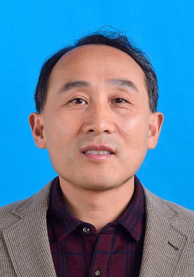
龚建华,男,1965年生,浙江海盐人,现为中国科学院遥感与数字地球研究所研究员,博士生导师。1995年获北京大学遥感与地理信息系统研究所理学博士学位,1995至2001年在中国科学院资源与环境信息系统国家重点实验室以及香港中文大学地球信息科学联合实验室完成两期博士后研究。目前任遥感科学国家重点实验室“遥感地学图谱分析研究室”主任,“浙江中科空间信息技术应用研发中心”主任,中科院遥感所与天津城建学院“数字城市与虚拟现实实验室”副主任, 国际数字地球协会虚拟地理环境专业副主任委员,中国地理信息系统协会医学地理学专业委员会副主任、中国计算机学会虚拟现实与可视化技术委员会委员,西南交通大学、上海大学兼职教授等。近年来原创性地提出与发展“虚拟地理环境”概念与系统框架,虚拟地理环境已成为地理信息科学领域的重要研究方向。主要研究方向包括地图与地学可视化、健康GIS、虚拟地理环境。2002年来,主持并参与了国家自然科学基金、国家科技重大专项、国家863计划、国家支撑计划等50余个国家级和省级科研项目,在国内外杂志和会议上发表学术论文160余篇(SCI检索论文40余篇),出版专著4部(其中译著1部)。已指导培养研究生47位(24位博士与23位硕士)。
虚拟地理环境网站: www.vgelab.org
近年来代表性成果
学术论文:
1. Wenhang Li, Jianhua Gong*, Ping Yu, Shen Shen, Rong Li, Qishen Duan. Simulation and analysis of congestion risk during escalator transfers using a modified social force model. Physica A: Statistical Mechanics and Its Applications, 2015,420: 28-40.
2. Liang, J., Gong, J., Zhou, J., et al., 2015. An open-source 3D solar radiation model integrated with a 3D Geographic Information System. Environmental Modelling & Software, 64, 94-
3. Li Y., Gong J.H., Liu H., Zhu J., Song Y.Q., Liang J.M., (2015), Real-time flood simulations using CA model driven by dynamic observation data. International Journal of Geographic Information Sciences, 29(4) :523-535.
4. Li Y., Gong J.H., Song Y.Q., Liu Z.G., Ma T., Liu H., Shen S., Li W.H., Yu Y.Y., (2015), Design and key techniques of a collaborative virtual flood experiment that integrates cellular automata and dynamic observations. Environmental Earth Sciences, 74:7059–7067.
5. Feng Quanlong, Gong Jianhua, Liu Jiantao, Li Yi. Flood Mapping based on Multiple Endmember Spectral Mixture Analysis and Random Forest Classifier – The Case of Yuyao, China [J]. Remote Sensing, 2015, 7(9): 12539-12562.
6. Wenyi Sun, Jianhua Gong, Jieping Zhou, Yanlin Zhao, Junxiang Tan, Abdoul Nasser Ibrahim, and Yang Zhou. A Spatial, Social and Environmental Study of Tuberculosis in China Using Statistical and GIS Technology. International Journal of Environmental Research & Public Health, 2015, 12(2):1425-1448. doi:10.3390/ijerph120201425.
7. Li Rong, Jianhua Gong, Liangfu Chen, Zifeng Wang. Estimating ground-level PM2.5 using fine resolution satellite product in the megacity of Beijing, China. Aerosol and Air Quality Research. 2015,15(4): 1347-1357. 8. Liu, Po, Jianhua Gong*, and Miao Yu. Visualizing and analyzing dynamic meteorological data with virtual globes: A case study of tropical cyclones. Environmental Modelling & Software 64 (2015): 80-93.
9. Wenhang Li, Jianhua Gong, Ping Yu, Shen Shen,Rong Li,Qishen Duan,2014. Simulation and analysis of individual trampling risk during escalator transfers. Physica A: Statistical Mechanics and its Applications, ,408:119–133,http://dx.doi.org/10.1016/j.physa.2014.03.071
10. Liang, J., Gong, J., Li, W., & Ibrahim, A. N., 2014. A visualization-oriented 3D method for efficient computation of urban solar radiation based on 3D-2D surface mapping. International Journal of Geographical Information Science, 28(4), 780-798.
11. Liang, J., Gong, J., Li, W., & Ibrahim, A. N. , 2014. Visualizing 3D atmospheric data with spherical volume texture on virtual globes. Computers & Geosciences, 68, 81–91
12. LI YI, GONG Jianhua, ZHU Jun, SONG Yiqian, Hu Ya, Ye lei. Spatial-temporal simulation and risk analysis of dam-break flooding based on cellular automata. International Journal of Geographic Information Sciences. 2013. DOI: 10.1080/13658816.2013.786081
13. Yiquan SONG, Jianhua GONG, Yi LI, Tiejun CUI, Liqun FANG, Wuchun CAO. Crowd evacuation simulation for bioterrorism in micro-spatial environments based on virtual geographic environments. Safety Science, 2013(53):105-113.
14. LI YI, GONG Jianhua*, ZHU Jun, SONG Yiqian, Hu Ya, Ye lei. Spatial-temporal simulation and risk analysis of dam-break flooding based on cellular automata. International Journal of Geographic Information Sciences. 2013. DOI: 10.1080/13658816.2013.786081
15. Yiquan SONG, Jianhua GONG, Yi LI, Tiejun CUI, Liqun FANG, Wuchun CAO. Crowd evacuation simulation for bioterrorism in micro-spatial environments based on virtual geographic environments. Safety Science, 2013(53):105-113.
16. Jianhua Gong, Yujuan Yue, et al. Impacts of the Wenchuan Earthquake on the Chaping River upstream channel change. International journal of remote sensing,Vol. 33, No.12, 20 June 2012, 3907–3929.
17. LI YI, GONG Jianhua, ZHU Jun, YE Lei , SONG Yiquan , YUE Yujuan. Efficient dam break flood simulation methods for developing a preliminary evacuation plan after the Wenchuan Earthquake,2012,Nat. Hazards Earth Syst. Sci., 12, 1-10, 2012. online:Doi 10.5194/nhess-12-97-2012
18. Hu B S, Gong J H, Zhou J P, et al. Spatial-temporal characteristics of epidemic spread in-out flow––Using SARS epidemic in Beijing as a case study. Sci China Earth Sci, 2012.ISSN:1674-7313 online:Doi 10.1007/s11430-012-4479-z
19. HU BiSong, GONG JianHua, SUN Jun & ZHOU JiePing,2012. Exploring the epidemic transmission network of SARS in-out flow inmainland China. Chinese Science Bulletin.ISSN:1001-6538 10.1007/s11434-012-5501-8
20. Yiquan Song, Jianhua Gong, et.al. Susceptibility Assessment of Earthquake-Induced Landslides Using Bayesian Network: A Case Study in Beichuan, China. Computers & Geosciences, 42 (2012),189–199 online:Doi http://dx.doi.org/10.1016/j.cageo.2011.09.011
21. Wenhang Li, Jianhua Gong, Ping Yu, Qishen Duan & Yuling Zou (2012): A stream-based Parasitic Model for implementing Mobile Digital Earth. International Journal of Digital Earth.2012,1-15. online:DOI 10.1080/17538947.2012.684070
22. DongchuanWang,Jianhua Gong, Liding Chen, Lihui Zhang, Yiquan Song, Yujuan Yue. Comparative analysis of land use/cover change trajectories and their driving forces in two small watersheds in the western Loess Plateau of China,2013.21:241-252. Online: Doi http://dx.doi.org/10.1016/j.jag.2012.08.009,
23. DongchuanWang,Jianhua Gong, Liding Chen, Lihui Zhang, Yiquan Song, Yujuan Yue. Spatio-temporal pattern analysis of land use/cover change trajectories in Xihe watershed.Inetrnational Journal of Applied Earth Observation and Geoinformation,2012.14:12-21.online: Doi http://dx.doi.org/10.1016/j.jag.2011.08.007
24. Bingli Xu, Hui Lin, Jianhua Gong, Sammy Tang, YaHu, Ibrahim Abdoul Nasser, Tao Jing,ntegration of a Computational Grid and Virtual Geographic Environment to Facilitate Air Pollution Simulation. Computers & Geosciences.2012.09.031,,http://dx.doi.org/10.1016/j.cageo.2012.09.031
25. Jianhua Gong, Dongchuan Wang, Yi Li, Lihui Zhang, Yujuan Yue, Jieping Zhou, Yiquan Song. Earthquake-Induced Geological Hazards Detection under Hierarchical Stripping Classification Framework in Beichuan Area. Landslide,2010,7:181-189,online: DOI 10.1007/s10346-010-0201-4.
26. Hui Lin, Jun Zhu, Jianhua Gong, Bingli Xu, Hua Qi. Grid-based Collaborative Virtual Geographic Environment for the Planning of Silt Dam Systems. International Journal of Geographical Information Science. 2010, 24(4):607-621.
27. Huang, Mingxiang, Gong, Jianhua, Shi, Zhou and Zhang, Lihui(2009)'River bed identification for check-dam engineering using SPOT-5 image in the HongShiMao watershed of the Loess Plateau, China,International Journal of Remote Sensing, 30:8, 1853-1865.
28. 龚建华,2013. 论虚拟地理实验思想与方法. 测绘科学技术学报,30(4):399-408.
29. 胡碧松, 龚建华*, 孙麇,周洁萍. 中国内地 SARS 输入输出流的疾病传播网络分析. 科学通报, 2013, 58: 452–464 . (*通讯作者)
30. 龚建华,周洁萍,张利辉,2010.虚拟地理环境研究进展与理论框架.地球科学进展,25(9):915-927;
31. 龚建华, 周洁萍, 胡碧松, 方立群, 曹务春,2009. 论医学地理信息科学与技术的发展. 遥感学报, 2009增刊, 255-265.
32. 龚建华, 2009. 地理信息科学研究发展. 遥感学报, 2009增刊, 195-202.
33. 王伟星,龚建华,2009. 地学知识可视化概念特征与研究进展. 地理与地理信息科学,25(4): 1-7.
34. 龚建华,李文航,周洁萍,李毅,赵琳,庞毅,2009. 虚拟地理实验概念框架与应用初探. 地理与地理信息科学,25(1):18-21.
35. 李毅,龚建华,周洁萍等. 协同虚拟地理实验关键技术研究. 高技术通讯. 2010,20(4),431-435
36. 李文航,龚建华,周洁萍.协同虚拟地理教学环境的设计与实现. 武汉大学学报:信息科学版. 33(3):289-292,2008
37. 周洁萍,龚建华,王涛,汪东川,杨荔阳,赵向军,洪宇,赵忠明, 2008. 汶川地震灾区无人机遥感影像获取与可视化管理系统研究. 遥感学报. 12(6): 877-884. (汶川地震专刊)
38. 龚建华,赵忠明.四川汶川地震应急无人机遥感信息获取与应用. 城市发展研究. 15(3):31-32,2008
专著:
1. 张锦明,龚建华译著,2015,(英)道奇(Dodge,M.),(英)麦克德比(McDerby, M.),(英)特纳(Turner, M.)编著.地理可视化:概念、工具与应用.北京:电子工业大学.
2. 龚建华,李文航,马蔼乃,2012. 地理综合集成研讨厅方法与实践.北京:科学出版社.
3. 黄明祥,龚建华,张健钦,2012.松材线虫病害遥感监测与传播模拟研究.北京:中国环境科学出版社,144p.
4. 龚建华,林珲, 2001. 虚拟地理环境-在线虚拟现实的地理学透视. 北京:高等教育出版社.(2002年2月第二次印刷)
5. 龔建華,林琿著. 2002. 虛擬地理環境. 台湾五南圖書出版股份有限公司.(高等教育出版社授权后的台湾繁体版)
6. 陈阳宇. 数字水利[M].北京:清华大学出版社,2011.(李毅,龚建华撰写该书第九章“3S技术”,pp290-330)
7. Jianhua Gong, Wenhang Li, Yabin Li and Mingxiang Huang, 2009. Networked Collaborative Virtual Geographic Environments: Design and Implementation. Virtual Geographic Environments. Beijing: High Education Press, 2009,pp. 245-254. (专著章节)
获奖:
1. 2015年度教育部高等学校科学研究优秀成果奖(科学技术)自然科学奖二等奖:“面向地理实验的虚拟地理环境理论与方法研究。”(林珲,闾国年,龚建华,游雄,朱庆,陈旻,胡明远,徐丙立,朱军,温永宁)
2. 梁剑鸣、龚建华等全球可视化论文,获得SCI期刊Computer & Geosciences的Best Paper(2014). Jianming Liang, Jianhua Gong, Wenhang Li, Abdoul Nasser Ibrahim, 2014. Visualizing 3D atmospheric data with spherical volume texture on virtual globes, Computers & GeoSciences, 68: 81-91
3. 龚建华,城市地质信息三维可视化关键技术研究与应用,三等奖,天津市科学技术进步奖,2012-2-24,证书编号:2011JB-3-100-R5;
4. 2009年10月30日,龚建华与李文航,李毅,周洁萍等参加在北京召开的“第四届中国系统建模与仿真技术高层论坛”,发表“面向复杂性地理问题的虚拟研讨厅体系研究”学术论文,论文得到较大反响,被大会评为优秀论文一等奖;
5. 由汪东川、龚建华等撰写的“ Analysis of land cover changes using multi-source and multi-temporal images in loess hilly and gully regions”论文,于2009年5月25到29日在成都召开的“2nd International Conference on Earth Observation for Global Changes(EOGC2009)”国际会议上,荣获优秀论文二等奖。
6. 2008年汶川地震抗震救灾中获中科院遥感所杰出贡献奖,获中科院京区“创新为民,科技救灾”先进个人。
7. 水利部黄河水利委员会创新成果奖:“小流域坝系规划三维可视化决策支持系统”,2007年获水利部黄河水利委员会创新成果应用技术类二等奖(证书编号:YJ-50-16-4-1)。
8. “黄土高原小流域坝系规划三维可视化决策支持系统”获2007年中国地理信息系统协会2007年地理信息系统优秀工程银奖。
专利申请与软件登记:
1. 一种基于无人机平台的四相机大幅面遥感载荷系统 (实用新型专利 ZL.2013 2 0849002.9 )
2. 高分辨率遥感影像道路信息提取系统,专利号:201110026501.3 (已受理)
3. 室内外一体化导航寻径系统,专利申请号:201220216633.2 (实审中)
4. 无人机影像的特征点模版匹配方法,专利申请号:201210213362.X,(实审中)
5. 虚实耦合洪水实验数据实时采集与模拟软件 V1.0 (软件登记 2014SR033729)
6. 基于GPU的浅水光学模型可视化系统V1.0 (软件登记 2014SR010790)
7. 基于RFID小区临时外来人员管理系统 (软件登记 2013R11S152983)
8. 基于RFID的老年室内活动行为管理系统 (软件登记 2013SR146241)
9. 基于元胞自动机的溃坝洪水模拟与三维可视化系统V1.0 登记号:2010SR071195
10. 突发生物危害时间三维仿真模拟系统软件V1.0 登记号:2011SR058616
11. 松材线虫病害传播元胞自动机模拟软件V1.0 登记号:2009SR052434
12. FDMT航空图像松材线虫病病害木提取软件(登记号:2009SR051799)
13. 马尾松高光谱曲线分析及健康状况探测软件V1.0 登记号:2009SR051800
14. 移动式松材线虫病害木定位和调查信息系统软件V1.0 登记号:2009SR019698
15. 人机交互的可视化坝系规划系统软件V1.0 登记号:2009SR036158
16. 肾综合征出血热防治决策应用系统软件V1.0 登记号:2009SR015564
17. 移动式生物危害评估模拟系统软件(简称:BIA-Eva)V1.0 登记号:2009SR037297
18. 城市地上地下一体化数据集成处理系统V1.0(简称:IPST3DUD) 登记号:2008SR15043
19. 城市地上地下一体化三维可视化分析V1.0 (简称:VAS3DUE) 登记号:2008SR15042
20. 传染病现场调查与分析移动技术平台软件V1.0 登记号:2011SR020554
u 多用户协同地学可视化系统软件V1.0 登记号:2009SR036646
社会兼职:
1. 2016年,受聘为国际数字地球协会虚拟地理环境专业副主任委员;
2. 2016年,受聘为中国环境科学学会环境信息化分会委员;
3. 2015年10月,受聘为北京中关村大成智慧教育产业创新联盟专家委员会委员;
4. 2012年4月,受聘为中国虚拟现实艺术研究中心高级专家委员;
5. 2012年1月,受聘为中国计算机学会虚拟现实与可视化技术委员会委员;
6. 2011年7月,受聘为西南交通大学兼职教授;
7. 2010年6月,受聘为科学出版社《钱学森科学技术思想研究丛书》编委会成员;
8. 2010年8月,受聘为科学出版社《地球观测与导航技术丛书》编辑委员会编委。
9. 2010年, 受聘为中国地理学会医学地理专业委员会副主任委员;
10. 2007年9月,受聘为上海大学兼职教授;
11. 2005年3月,受聘为成都电子科技大学兼职教授;